Author Archives: ads135

Disparity and Solidarity: Reflections on the Christmas Flood of 1717

The following are additional thoughts (and maps) that could not be included in my presentation during ESEH 2017. The paper as well as the powerpoint presentation, entitled “Boundless Water, Bordered Lands” can be found on my academia.com site for download.

Disasters are always disproportionate. They affect some people, some environments, and some social systems far more than others. Teasing out the reasons for these disparities and exploring their consequences and origins have been some of the more significant and consistent threads of natural disaster research over the past several decades. The social science of disaster often focuses on these questions and the way in which they challenge or reinforce existing social disparities. How do issues of gender, race, religion, or class affect the outcomes of disasters? Economically and socially disadvantaged groups, or groups without access to the political power necessary to mediate recovery, tend to lose most in the wake of disaster. These observations have taken on the importance of near-truisms, particularly in the realm of vulnerability studies. Historians of natural disaster have an important role to play in this dialogue. History provides a wealth of additional examples to test assumptions about the interplay between social and natural systems that create vulnerabilities and moderate social resilience (Van Bavel & Curtis) Just as importantly, as Greg Bankoff has previously asserted, vulnerability itself is an historical construct. (Bankoff, Time is of the Essence) The social hazards of living in low-lying areas, building wooden houses unable to withstand earthquakes or fires, or organizing communities without access to centralized disaster relief are products of far deeper histories of disenfranchisement and vulnerability.

In the context of the Christmas Flood of 1717, we see the truism of disaster disparity starkly reified. Although the flood is often considered a true “North Sea Flood,” affecting a huge area of its southern coastline, in reality, its impact was far from homogeneous.

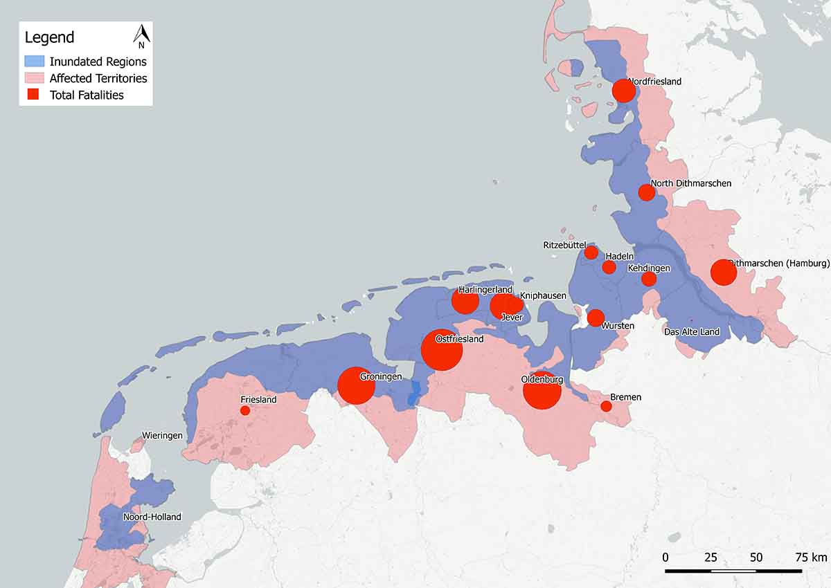
Figure 3- The size of red circles represents the proportion of total losses during the Christmas Flood as reported in Jan Buisman, Duizend Jaar Weer, Wind En Water in de Lage Landen. Deel 5: 1675-1750. Franeker: Van Wijnen, 2006. It should be noted that the spatial extent of the Christmas Flood has been a source of consistent debate and extensive analysis. Already in 1720, G. Outhof criticized the accuracy of Homann’s map, from which this layer is derived. The most extensive critical analysis of this map can be found in D. Hagen Die jämmerliche Flut von 1717; Untersuchungen zu einer Karte des frühen 18. Jahrhunderts, Oldenburg 2005. Sources: Inundated regions derived from Homann, Geographische Vorstellung der jämmerlichen Wasser-Flutt in Nieder-Teutschland, 1718. Territorial boundaries modified from 1830 provincial data. Dr. O.W.A. Boonstra (2007): NLGis shapefiles. DANS. https://doi.org/10.17026/dans-xb9-t677. German territories modified from 1815 provincial data, MPIDR [Max Planck Institute for Demographic Research] and CGG [Chair for Geodesy and Geoinformatics, University of Rostock] 2011: MPIDR Population History GIS Collection (partly based on Hubatsch and Klein 1975 ff.) – Rostock. Hubatsch, W. and T. Klein (eds.) 1975 ff.: Grundriß der deutschen Verwaltungsgeschichte – Marburg. http://www.censusmosaic.org/data/historical-gis-files

The degree to which this was the case is rarely the subject of research. In his book Sturmflut 1717, now a classic of the new disaster history, Manfred Jakubowski-Tiessen examines the flood and its impacts with a broad comparative lens. Although he wrote the book before the recent upswing in vulnerability studies, one could make the argument that the concept was central to his interests. The flood, as he describes it, catalyzed a strong and protracted economic and demographic decline in key areas, particularly the Butjadiger coast of Oldenburg, the Dithmarschen and East Frisia. He explores each as part of a larger flood disaster narrative that focuses on themes of cultural, social, and economic significance. Jakubowski-Tiessen limits himself, however, to German-speaking lands and as a result, the full power of his argument is difficult to conceptualize. How did the impact of the flood in East Frisia, for instance, compare with non-German-speaking areas affected by the flood?

Jakubowski-Tiessen’s book remains the seminal work on the Christmas Flood, though it does not cover the consequences in the Dutch Republic.

I explored this question in my conference paper, called “Boundless Water, Bordered Lands,” for the European Society of Environmental History Biennial Conference in Zagreb, Croatia in July 2017. I choose for my comparison the Dutch Province of Groningen and the “German” province of East Frisia. On paper, they appear complementary. They experienced roughly equivalent losses in human lives and property in the immediate aftermath of the flood. Almost immediately, however, their experiences diverged. Groningen quickly rebounded, whereas East Frisia proved far less resilient. Why was this the case?

Explanations might be sought in the type of dikes or their management. Both regions, however, constructed roughly similar coastal defenses maintained and financed by similar dike institutions (dijkrechten in Groningen, deichachten in East Frisia). Less proximate similarities run deeper still. Groningen and East Frisia were (and are) part of the Frisian cultural zone bordering the Wadden Sea, a thin intertidal space sandwiched between the mainland and an archipelago of barrier islands. For centuries, people living along the coast exploited the rich sea clay and interior peat soils and developed communities that shared numerous cultural, linguistic, and economic conditions. The similarities between dikes and dike institutions in East Frisia and Groningen were partly derivative of this deeper history and more recently, historians have explored their underlying unity in the context of shared vulnerabilities, adaptation, and resilience to coastal flooding. Variously termed a “coastal culture of disaster,” “hydrographic society,” or “amphibious society,” these concepts have been applied to communities along the entire North Sea coast, but tend to highlight particular relationships in coastal Germany and Holland.

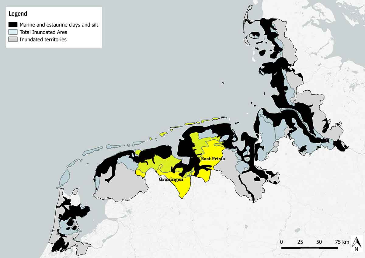
Figure 1- The sea clay coastline of the North Sea was hardest hit, with the majority of fatalities located here. Sources: Inundated regions derived from Homann, Geographische Vorstellung der jämmerlichen Wasser-Flutt in Nieder-Teutschland, 1718. Territorial boundaries modified from 1830 provincial data. Dr. O.W.A. Boonstra (2007): NLGis shapefiles. DANS. https://doi.org/10.17026/dans-xb9-t677. German territories modified from 1815 provincial data, MPIDR [Max Planck Institute for Demographic Research] and CGG [Chair for Geodesy and Geoinformatics, University of Rostock] 2011: MPIDR Population History GIS Collection (partly based on Hubatsch and Klein 1975 ff.) – Rostock. Hubatsch, W. and T. Klein (eds.) 1975 ff.: Grundriß der deutschen Verwaltungsgeschichte – Marburg. http://www.censusmosaic.org/data/historical-gis-files; The European Soil Database distribution version 2.0, European Commission and the European Soil Bureau Network, CD-ROM, EUR 19945 EN, 2004.

East Frisia and Groningen are an ideal region for comparative analysis because of these and other connections. East Frisia, for instance, can be thought of as a near satellite of the Dutch Republic during the seventeenth and early eighteenth century. The largest city in the state, Emden, was arguably politically (and certainly culturally) closer to the neighboring Netherlands than the court of Aurich in the interior of the region. These East Frisians spoke Dutch, practiced Calvisinism, and were united in their antipathy for the Lutheran Princes of the Cirksena family that claimed sovereignty over the principality. The surface similarities between the two regions, however, were also the sources of subsequent tensions that would push Groningen and East Frisia onto diverging paths of recovery.

In the conference paper, I argued that the conflict between Prince Georg Albrecht and his Calvinist subjects along the sea clay coasts was a significant contributor to the divergent path East Frisia would take from Groningen in the aftermath of the Christmas Flood. The flood created severe financial difficulties and sparked social unrest in both regions (the Aduard uprising in 1718 in Groningen, and the Appelle Krieg of 1726 in East Frisia). In contrast to the Aduard uprising, which was highly localized to the lightly affected Western Quarter of Groningen, the East Frisian resistance exhibited far greater solidarity and power in the face of their Lutheran Prince. The indirect (and unintended) consequence of this solidarity was inaction in rebuilding their own dikes. Financial troubles were compounded by regional resistance to state-directed rebuilding efforts, which inhabitants viewed as a breach of their traditional rights. Subsequent floods in 1718 and 1720 destroyed what little repairs could be completed. Ultimately, it would take over 6 years to rebuild the dikes, during which time the landscape had remained susceptible to inundation, harvest failure, and continual out-migration. We should be very careful to contextualize historical interpretations of solidarity, particularly after floods. Communities could rely on multiple avenues to achieve solidarity, but they weren’t necessarily productive and didn’t always involve a recognition of shared risk to natural hazards (the presence of which disaster culture historiography depends on to a great extent).

During the question and answer period, Richard Unger asked what distinction should be made between “communities” and people with “shared interests” – an important distinction to be sure, but one that is often taken for granted in the historiography of “disaster cultures.” Most scholars who have weighed in on the subject, I think, would argue that shared interest in the face of natural hazard partly defined those communities’ cultures. These understandings were constantly contested and ever-changing, just as the broader cultures themselves evolved. Whether we can then transcend key differences and negotiate the shifting landscape of these relationships to find a “model” representative of all Wadden Sea cultures of coping with disaster remains an open question. The solidarity expressed by coastal communities in East Frisia in the aftermath of the Christmas Flood sharply contrasted with those in Groningen. This example demonstrates how issues of post-disaster solidarity, interest, and community were contingent on the underlying political and social issues at play in the wake of single disastrous events.

Next post: exploring the geography of vulnerability and the potential intersection of multiple disastrous events.

ESEH 2017 – Borders, Animals, and Nature

Conference themes don’t always (or even typically) define their content. Whereas keynotes and panels organized by program committees generally adhere to them, other sessions and events or just as likely to ignore the themes entirely. This is part of the reason that I rarely remember them. Conference “character” is more often defined by location, socializing, and/or interesting papers. In some exceptional circumstances, conferences can even be defined by their weather (such as the extreme heat of ESEH in Versailles). Effective themes, however, can provide a backbone of connectedness and dialogue between and amongst the disparate sessions, events, and meetings throughout the conference. ESEH 2017 in Zagreb adhered to this second model. Although not always fluidly executed, the conference as a whole nevertheless consistently explored its theme of “Natures in Between: Environments in areas of contacts among states, economic systems, and religions.”

The two most explicit connections to these themes were drawn from the opening address and plenary roundtable about migration. Andrew Baldwin’s opening lecture provided a provocative (or to use his own word: uncomfortable) introduction to the theme. Ostensibly about climate migration, Baldwin’s talk became more of an anthropology of whiteness and the hypocrisy of post-racial narratives of migration. Baldwin had the fortune (or perhaps misfortune) of speaking on the first, and hottest day of the conference, in the gorgeous Croatian State Archives. Baldwin’s talk received mixed reviews. On the one hand, environmental historians found little of “environmental” significance in his talk (which was possibly the real source of people discomfort, rather than its racial subject matter). On the other hand, I, and I imagine others, appreciated Baldwin’s sort of iconoclasm and rejection of what has come to define “European” environmental history. European environmental history is heavily invested in theory, but far less in discourse and narrative analysis, both of which Baldwin drew heavily upon. As his talk revolved around forced movement of peoples, it absolutely fit the theme of the conference.

The opening lecture took place in the stately central hall of the Croatian State Archives.

In retrospect, it shouldn’t have been surprising how migration and movement became the watchwords of the conference. Between refugee crises and their consequences in Europe and apprehensions about the devolving state of immigration in the US, historians already interested in borders and their transgression found plenty of material for contemporary comparison. In addition to Baldwin’s talk, the plenary roundtable on migrations was another case in point. Also like Baldwin’s talk, it received mixed reviews. Starting off the discussion, Marco Armeiro’s first pitch to the panelists was an (intentional?) softball, asking each to react to his provocation – that environmental historians have largely ignored migration as a subject. Naturally they disagreed, and all for valid reasons, though most also emphasized the need for greater emphasis in the future. Shen Hou’s comments were particularly well put, drawing primarily from the “classics” of EH literature (Dust Bowl, Changes in the Land), but leaving plenty of room for future contributions. The discussion only truly took off, however, when the mic was offered to the audience. Although the quality of answers were mixed, thoughtful, challenging questions redirected the discussion into new and arguably more productive and innovative directions. Thinking about migration across borders as a normative condition, for instance, and sedentism as the questions requiring an answer, or substituting corporations for nation states in our dialogue of migration pushed the audience and panelists to rethink their assuptions. Naturally, this discussion could have gone on far longer. Peter Coates, for example, was brought into the discussion largely based on his expertise on historic invasive species, and I would have loved to hear his take on the limits to the animal-human analogies he was encouraged to make. Likewise, the consequences of language and labeling of “refugees,” “migrants,” and “invasives.” Regardless of its shortcomings, the plenary was a useful thematic bookend that recalled topics and themes related to “contact” areas from the previous days’ sessions.

Toon Bosch, Erik Mostert and I answer questions following our presentations (photo: Annka Liepold)

The most surprising development of the conference, however, was the “animistic turn” European environmental history seems to have taken over the last few years. Histories of animals (wolves, whales, cattle), animal movement (epizootics, bio-migrations) and non-human nature more broadly were conspicuous for the number of sessions devoted to them as well as their attendance. The experimental session on “more-than-human” storytelling had a packed house. It was an exercise in unstructured, team-brainstorming. Session leaders challenged groups of scholars to think through key methodological and epistemological questions about the nature of narrative storytelling, anthropomorphism/centrism, and agency. Although the intention was to de-center (at least temporarily) the human from historical thinking, it ultimately did the opposite. Thinking about “beyond-human” agency casts the significance of human action into even sharper relief. Its absence is clearly felt and significance expressed. This may be the single most useful contribution of this type of exercise.

In a certain sense, focusing on animals during the conference, in particular this exercise in non-human storytelling, were surprisingly appropriate subjects for this conference about borders and contact. Plenty of papers (my own included) dealt with historical subjects across state, economic, and religious borders. I found that the most interesting moments of the conference came when people crossed disciplinary borders (Baldwin), narrative borders (more-than-human panel) and made contact with the “Natures in Between” those spaces.

The plenary roundtable took place in the main university building adjacent the archives.

Travel & Familiarity – Research Blog Summer 2017

Displaying FullSizeRender.jpg

The Amsterdam Canals seen from the north. (this was actually the first time I’ve flown over the city on a clear enough day for this view).

Flying back to the Netherlands for another summer of research, conferences, and writing, I had expected the transition to occur awkwardly after about a year away. Eleven months is a long time to be gone. You’re in a different place with your work, friends and colleagues move their lives and interests, and the cities you’ve grown familiar with evolve. I find that I have to completely shift into a different head space come summer because so much of my time and energy during the year is spent teaching or working on other projects. The shift to research and writing full time is a welcome change, but one that has to take place quickly and deliberately. I have similar apprehensions every year, but I’m beginning to realize I shouldn’t. As much as people and places change and as much as I become engrossed in other projects after I leave, the underlying familiarity and warmth (well not literal warmth) of the Holland welcomes me back every year.

This was a nice realization and a starting point for my month-long stay in Europe this summer. It’s Tuesday June 27th and I’ve now been in Holland about a week. This is the first post of summer 2017 in a series detailing my research and time spent in Holland and abroad. It will be a busier than average summer, largely because I’m only here for 30 days (a short stay compared to last year), but also because so much of my time will be spent in transit. As in years past, I’m beginning the summer with a conference outside the Netherlands. The European Society for Environmental History (ESEH) is hosting their biennial conference in Zagreb, Croatia this year and I’ll be presenting on an old theme for the first time in years, coastal flooding! (More on this to come) I also have trips planned to Rome, Antwerp, and London. The latter will be short, a two-day stay near the National Archives at Kew. It will be my first time in British collections and a necessary next step in a slowly expanding project on West Feliciana, Louisiana. In later posts, I will detail my objectives and findings, but suffice to say, I will be doing a lot of writing on planes and trains.Logo_ESEH_2017

I also plan to take a weekend to visit Groningen. Groningen is a beautiful northern province, well worth a visit on any occasion. 2017 is perhaps the most ideal year to visit, however. This is the 300th anniversary of the Christmas Flood! In commemoration of this near-forgotten event, the province, the Groninger Archieven, and a number of cultural organizations have put together a summer-long program of lectures, excursions, and exhibits related to its history. They also have a fantastic website that links to primary and secondary sources (including one by yours truly) on the history and significance of the flood. Coincidentally, my conference paper for ESEH also explores the history of the Christmas Flood, so it was a completely natural decision to plan a visit. It also hasn’t escaped my attention that, with the exception of a couple Wadlopen excursions (and none since 2014), I’ve been a really poor visitor to the province (hardly ever leaving the center of Groningen). Time to remedy that.

2014-07-19 08.30.20.jpg

You can hike (or Wadloop) to the barrier islands at low tide from Groningen’s mainland. (2014 en route to Schiermonnikoog)

Somewhere amidst this travel, I will also have to find time to research and write. In contrast to last year’s narrow set of research goals, this year will be spent largely writing and wrapping up loose ends for my book manuscript, Floods, Worms, and Cattle Plague: Natural Disaster at the Closing of the Dutch Golden Age. With the exception of a few books and archival documents I need to find in The Hague, Groningen, and Amsterdam, the research is largely complete (or at least as complete as it will be). My time will be largely spent writing and editing the manuscript and my goals for the summer are consequently related to that process.

Goals:

  1. Complete a draft of chapter one. This chapter frames the core issues of the book. It explores the meaning of disaster in the early modern era and how it tied in to the eighteenth-century decline of the Dutch Republic. In contrast to later chapters that address individual disasters and more defined and limited themes and time periods, this chapter performs a balancing act between narrative explanation of themes and questions (often in the longue durée) and the narrative specificity of my hook, the famous disaster year (rampjaar) of 1672.
  2. Writing the first chapter requires dealing with a theme that has received far less scholarly attention than I would have expected– the decline of the Dutch Republic. Although decline has enjoyed substantial attention from economic historians since the publication of Joh. de Vries Economische achteruitgang der Republiek in de achittiende eeuw (1968), far fewer scholars investigate the subject from its cultural or social perspectives, much less environmental. This peculiar historiographic oversight will be a subject for a later post, but suffice to say for now that I will be able to investigate the topic more effectively in such close proximity to the archives and especially libraries of the Netherlands.
  3. Begin revision of Christmas Flood chapter. It is not the second chapter, but I may as well turn to it next since so much of this summer revolves around the disaster anyway. This is easily one of the more polished chapters already, but there are a few documents I need to find in the Groningen archive.

Next post, from Zagreb!

Final Post

This will be the final post of my research blog for this summer. I’ll be flying out of Holland tomorrow and I’m reminded how leaving is always bittersweet. From a personal perspective, a month and half is an awkward length of time to live abroad. Not long enough to really feel settled, but certainly long enough to feel a significant amount of distance develop between your everyday experiences and those happening back home. This summer in particular, I was very fortunate that my research trip coincided with moments of great transition in the lives of friends and colleagues in the Netherlands. I’ve seen them get engaged, start families, and start new jobs. I’m very grateful to have been able to share in those experiences. From a professional perspective, no place beats the Netherlands for my research and this has been one of the most productive periods of my (albeit very new) professional life. With the archives, libraries, colleagues, and landscape of the Netherlands a stone’s throw away, reading, writing, and thinking about Dutch environmental history seems a natural outgrowth of waking up every day. One day out from the journey home, therefore, it’s relatively easy to take stock of what has been achieved.

Interior of the Regionaal Archief Rivierenland in Tiel. A wonderful source of information about the 1740-41 river floods.

I laid out three broad research goals in the first installment of the 2016 research blog and I’m happy to report progress on each.

1. My first goal was to get to the bottom of some historiographical inconsistencies I discovered concerning the early years of the shipworm epidemic. I elaborated on these problems in some detail in my first blog on the “unusual connections” between disasters so I won’t rehash them here. In short, the beginning of the shipworm epidemic is often dated to November 1730. According to most accounts, this was the first verifiable, consistent, explosive outbreak of the species in Dutch waters (though there is some evidence of wood borers and perhaps even Teredo navalis earlier). Several historical accounts, however, report an earlier outbreak in 1728 on the island of Goeree.(1) In my earlier blog, I noted how difficult it had been finding evidence of this supposed outbreak. The notes from the “Statenvergadering” of the Estates of Holland on 19 Aug, 1728 certainly mentioned the island and its wooden piles, but there was no mention of shipworms. The notes of a subsequent report presented in the Spring of 1729 likewise turned up no evidence of shipworms. Even following a severe storm in December of 1729 when numerous piles had been broken (the exact situation that would prompt discovery of the shipworms in Zeeland and Holland in 1730/31 respectively), the notes make no mention of the mollusks.

An example of a “resolutiekaart” found the resolutions of the Estates of Holland. This hand drawn map accompanied a report from surveyor Abel de Vries on the condition of the dikes along the Merwede river in the Land of Althena. The map was part of an effort to visualize disaster mitigation strategies in the aftermath of the 1726 Flood.

In fact, no mention was made of shipworms in the notes of the Statenvergadering through December 1731, even after they had been discovered in other parts of Holland!

The notes of the Statenvergadering are not the only source of information about the institutional management of water, however. The resolutions of the Estates General of Holland are a treasure trove of information. Intermixed with terse, economical notices of import restrictions, subsidies for the herring fishery, and official appointments of individuals into the bureaucracy of Holland are numerous extended reports (including correspondence, notes, and maps) of water and disaster management.(2) Perhaps this rich source of information could resolve this situation, but I would have to travel to Amsterdam to find it.

Also called the “spekkoek” for its visual similarities to the Dutch-Indonesian layer cake, the city archives of the Netherlands are housed in the Gebouw de Bazel, a Rijksmonument.

The Stadsarchief (city archive) of Amsterdam is a wonder of the archival world. Housed in the fantastic “De Bazel” building (a Chicago-style Rijksmonument on its own, built in the early 20th century), it is also one of the most well organized, digitally accessible archives I’ve ever used. Their comprehensive collection of the printed resolutions of the Estates of Holland (complete with indexing, thankfully), I expected, could offer quick insight into this problem.

Indeed, a resolution on the 10th of April 1728 noted the necessity of inspecting Goeree because “the earlier inspection is now already two years old, and in the meantime, the state of the island and the course of the current and the depths could be notably changed.”(3) The “provisional report,” however, would only arrive in 1732. An inspection at the beginning of July 1732 noted “all of the pileworks on the south side of the island are infected by the shipworms.”(4) This is the smoking gun and one that had not appeared previously in the literature. Judging from the subsequent descriptions of the mollusks in the provisional report (similar in language and detail to the “first impressions” of the shipworm elsewhere), this was likely their initial encounter. Goeree may have experienced shipworm damage at an earlier date, but this was likely the first official account in Holland. Thus, the more established historiography dating the shipworm outbreak to Zeeland seems to hold. Considering the fact that it was the Zeelandic accounts dating to 1730 that would later circulate in West Friesland rather than from Goeree (part of the same province), it makes sense that shipworms would have appeared later in the island’s records.

2. A second goal of the trip was to find new datasets for cattle plague numbers and mortality between 1769-1780. This information is necessary for a collaborative project between Filip van Roosbroeck and myself. The core question of our study is to determine why some regions of the Netherlands were more strongly impacted by the cattle plague epidemics than others.

The Historisch Centrum Overijssel has the added benefit of being located in scenic Zwolle.

Our original ambition was to compare regions in Flanders (Van Roosebreuck’s study area) with those of comparable regions in the Netherlands. Based on Filip’s prior work on the Austrian Netherlands, his hypothesis was that market-oriented regions (typically coastal areas) would have greater susceptibility to the outbreaks, whereas areas with less market-driven use of cattle (for instance, in the production of fertilizer and/or small-scale dairying) would be less susceptible. For this reason, I traveled to the cities Arnhem and Zwolle to find out whether their archives contained useful data series (either from mortality records or tax records on number of cattle, called hoorngeld). Our intention was to compare these eastern regions with coastal Holland and Friesland. This approach was derailed for several reasons. Firstly, because colleagues suggested that the Netherlands and the Austrian Netherlands (now Belgium) were not overtly comparable in their market-orientation or their environments. Second, I quickly discovered that the necessary data simply does not exist from the regions of the Overbetuwe (in Gelderland) or Twente (in Overijssel). As a result, we reformulated our hypothesis to address a similar question, albeit with a more tightly defined scope. What explains the regional variation within the province of Holland?

Holland is an ideal study area because of the richness of its records.

The Alkmaar Cheese Market. Alkmaar has had an operational market for centuries and the first cheese “scale” in the weigh house dates to the 14th century.

The province required municipalities to produce data series noting the number cattle infected, killed, and recovered. Despite having already collected a fairly detailed account of cattle mortality on previous research trips in Holland, we still had a small amount of archival research to do. An important subset of years at the outset of the epidemic in the early 1770s was completely absent from our records. Luckily, the Regionaal Archief Alkmaar had comparable records (though in a slightly different format). This archival visit had the added benefit of being on a Friday. Alkmaar holds their famous kaasmarkt (cheese market) Friday mornings during the summer. Although incredibly touristy, the cheese market hearkens back to the significance of this part of Holland in the early modern dairying economy. The Alkmaar kaasmarkt has a rich tradition and it’s located in the middle of an incredibly scenic, well preserved city center, but it was impossible on this particular day to observe the event without thinking about how dramatically the rinderpest epidemics of the eighteenth century would have affected this area. The research trip was successful. Having collected the data, we can now move forward with analysis. We plan to focus on the Gooi area and possibly the environmentally/culturally unique riverlands to the south, though the data and available literature will likely dictate our final decision.

3. My final (and largest) goal was to collect archival material and conduct preliminary secondary research on a river-flooding project. This was my most pressing assignment. Not only will this work be part of a collaborative research article with Toon Bosch, but I will also likely present the results of this research at the Annual Meeting of the American Historical Association in 2017 and possibly use this as the core of a final chapter for my manuscript. Aside from getting a sense of the scope of the floods and learning the history of the Dutch Rhine and Meuse (see blog), I was interested in the intersection between climate, flooding, and institutional management of the rivers in the 18th century. To what extent did river flooding in the Netherlands change in scope or severity? Did contemporaries recognize any shift and did they connect this to environmental changes? How did institutional management strategies adapt to any changes?

The floods of the 1740s run counter to the prevailing long term trends in river flooding. It should be noted that this graph notes frequency, not severity. Contemporaries of these floods felt that floods had been getting worse, not necessarily more frequent. Source: Glaser et al. “Historical Floods in the Dutch Rhine Delta,” Natural Hazards and Earth Systems Sciences (2003), 608.

Although still early in the process, my research has already yielded some surprising results. The floods of 1740-41 (which are my primary interest) were rather unique in origin. The floods did not occur during a period of increasing river flooding on a continental scale. Environmentally, one could even argue they were flukes. Unlike many of the river floods of the 18th and 19th centuries, these were NOT the result of ice dams. Ice dams occur when frozen sections of the rivers block discharge resulting from quickly melting snow pack (often coinciding with heavy rainfall). Ice in the lower reaches of the rivers block the discharge, forcing water over the dikes resulting in breaches. River flooding along the Dutch Rhine and Meuse are complex beasts, however, and not all floods followed this formula. This is partly because the rivers themselves are quite different. The Meuse is rain fed; whereas the Rhine’s discharge depends on both precipitation and snow melt in the Alps. The floodplains of the Rhine and Meuse interact closely in South Holland and Gelderland, but massive inundations require concurrent extreme events in the upper reaches of both river systems. The final piece of the puzzle is the human interactions with the river systems. Over the course of the early modern period, the human element would gain in relative significance. The steadily shrinking lands outside the dikes (because of drainage and peat excavation), coupled with increased sedimentation over the course of centuries necessitated increasingly higher dikes in a classical technological lock-in scenario. When a heavy rainfall event like that which occurred during the winter of 1740-41 occurred, dike breaches could occur in multiple locations.

The response was swift, but not coordinated. Cities were largely responsible for rescuing citizens in their hinterlands (a management strategy codified following the disastrous 1726 floods in the same region). Cities struggled to cope with their own inundations in the 1740s, however. Woudrichem and Heusden, for instance, were also inundated and did not have the capacity to extend help to their hinterlands. The Staten van Holland, meanwhile, offered subsidies, but no direct support. The floods of 1740-41 are well known for being the first flood recovery financed partly from citizens outside the affected regions, but help was belated and could not compensate for the extensive damages.

The final page of a special commission report on the states of dikes following the 1741 floods. The report was conducted by Willem Jacob s’Gravesande and Melchior Bolstra.

The most significant response on the part of the provinces came in the form of advisory commissions established to investigate flood vulnerability in the riverlands. The same cast of characters employed to assist in the repair of the West Frisian dikes (and previous river floods) were once again asked to lead the “scientific” investigation into the disaster. The Leiden professor Willem Jacob ‘s Gravesande and the surveyor of Rijnland Melchior Bolstra presented a report on the 24th of January 1741 detailing their suggestions. They suggested lowering the dams of the creeks to ease the pressure on the main channel, but to also encourage increasing streamflow to the sea. Their advice was the first in a protracted battle between the provinces and cities in the floodplains of the Rhine and Meuse. Despite intense interest and significant resources dedicated to the study of the river system, significant technological adaptation would be delayed until the 19th century. In the meantime, the Dutch would endure over a century of intense river flooding.

This is just one small part of the larger story of societal response and environmental change in the mid 18th century. Although the flooding seems environmentally disconnected from larger continent-scale climate changes and resulting increases in river floods, they were VERY connected to larger scale cultural and social vulnerabilities. This is not the place to outline a complete argument (especially since I have only begun developing it), but suffice to say that Dutch vulnerabilities increased during the mid-18th century largely due to political, economic, and social conditions rather than climatic factors. Social and political conflicts arising from the unique forms of “wet system building” established in the Netherlands created conditions conducive to short term adaptation, but not coordinated river management. (5) Communities tasked with maintaining dikes and provinces tasked with clearing stream-beds seemed perpetually at odds with one another and both suffered from lack of resources. Climate and society always participate to some degree in the causal dance of river flooding. The challenge for the future of this project will be to tease out their relative importance.

Although my research this summer has primarily focused on these three broad subjects, small side projects and trips occupied significant time as well. The products of several of these detours can be found in earlier blog posts. At the same time, one cannot research every day (archives aren’t open on the weekends after all…) Bike trips through the river valleys of the Meuse (in Limburg) and the Waal (in Gelderland) and the polder landscape of Leiden were fascinating introductions to landscapes I could only otherwise read about.

A vision of the boezem collecting and storing pumped polder water for eventual discharge into the Rhine. This photo was taken while biking with environmental historian Petra van Dam through the farmlands to the south of Leiden.

Donald Worster once advised my cohort of graduate students at KU to “get our boots muddy.” Environmental history, he reminded us, was first and foremost grounded in material places. It’s dirt, water, fungus, and worms. History is found in these elements just as much as it is found in centuries-old dike reports, maps, and government resolutions. I’ve done my best this summer to utilize both sets of information. I’m currently writing this final post sitting in a train heading back to The Hague. It’s a dreary, rainy day in the Netherlands and my boots are sodden. The rainwater has largely washed off whatever mud they had collected over the last month and a half. When I fly out tomorrow, I may not be bringing the literal “dirt” of environmental historical work back with me, but that’s only partly what Don meant anyway. The mud is just what you pick up along the way. It’s a reminder of the journey. What I’m bringing back is much richer.

(1) Paul van den Brink, In een opslag van het oog’ : de Hollandse rivierkartografie en waterstaatszorg in opkomst, 1725 – 1754 (Canaletto, 1998); Gerard van der Ven, Leefbaar laagland: geschiedenis van de waterbeheersing en landaanwinning in Nederland (Matrijs, 2003).

(2) Paul van den Brink has written extensively on the use of resolutiekaarten. see: “Resolutiekaarten, de Staten van Holland en de Waterstaatskartografie 1699-1795,” Kartografisch Tijdschrift 14 (1988).

(3) “de voorschreeve inspectie gedaan is nu ruym twee jaaren geleeden, dat in die tusschentyd de staat van het selve Eiland, en de loop der Stroomen, en Dieptens, merkelijk konnen weesen verandert” SvH Resoluties. 10 Apr, 1728.

(4) “alle de Paalwerken aan de zuidzyde van het Eiland door de Zeewormen zyn geinfecteert.” SvH Resoluties. Aug 1732

(5) Erik van der Vleuten and Cornelis Disco, “Water Wizards: Reshaping Wet Nature and Society,” History and Technology 20.3 (2004), 291-309.

Shipworms in the news!

Door de paalworm glooit de dijk

In 1730 brak aan de Nederlandse kust een paalwormepidemie uit. De zeedijken bestonden toen veelal uit palenrijen, waarachter wier- of zeegraspakketten de aarden dijklichamen beschermden. Van Zeeland tot Friesland werden de palen door paalworm aangevreten. Hoe hebben de Nederlanders gereageerd op deze voor hen ongekende ramp, die het uiterlijk van het kustlandschap blijvend zou veranderen?

Post 3/3 – Disasters were all connected

In post 3/3 of my series on unusual connections, I want to broaden the scope my argument beyond simply river floods and shipworms. Disasters in the Dutch 18th century were all connected!

In a sense, this is the principal argument of my manuscript. The eighteenth century was (relatively) disastrous for the Dutch Republic.(1) After enjoying a century of prosperity, the Golden Age of Dutch economic success, artistic efflorescence, and political influence had begun to wane by the eighteenth century. Disasters reflected new anxieties about this change of circumstances just as they contributed to increasing financial pressures.

An anonymous pamphlet detailing the terrible consequences of the “hard winter” between 1739-1740. Anon. Een historiesch verhaal van veele en nooit meer gehoorde voorvallen, die geschiet zyn in verscheide harde winters, inzonderheid van den jaare 1709. en 1740

Natural disasters were certainly not new to the eighteenth century and there is no indication that they increased in number between 1650-1750, but the reaction to them shifted.(2) Natural disasters unearthed buried social tensions, prompted providential reevaluations, and produced intense reconsideration of the Dutch relationship with their environment. (3)

In this perfect storm of cultural, economic, and environmental uncertainty, contemporaries linked disasters together. Naturally, causal connections were stronger in some situations than others. Adverse weather, particularly harsh winters like 1740-1741, created numerous rippling effects and directly or indirectly contributed to several other demographic and environmental disasters. In addition to the direct consequences of frigid conditions (reports of cattle and sometimes even people dying from exposure abound), historians have indirectly connected adverse weather to a widespread mortality wave in the Netherlands and across Europe via failed harvests. (4) Furthermore, frigid conditions prompted the formation of ice dams on Dutch waterways. One can even connect these stressful environmental conditions to cattle plagues. Lack of fodder and prolonged exposure to adverse conditions likely weakened the immune systems of cattle making them more susceptible to disease. Rivers, on the other hand, had very little direct causal connection to the shipworm epidemic outside of the circumstances mentioned in these post.

Independently of direct environmental causation, however, contemporaries discursively linked the disasters of the 18th century. Rural communities merged disasters together in their petitions for remission from provincial taxation. The burden of rebuilding dikes in the wake of river floods (or shipworms) combined with the need to replenish cattle stocks after cattle plague epidemics) while also shouldering their usual tax burden, residents argued, was untenable.

Consideration for the remission of taxation related to the shipworm infestation in West Friesland. Source: Westfries Archief 1662.424

The most common discursive linkages were providential. Disasters pointed to God’s wrath and confirmed the sinful state of the Dutch Republic. Clergy and laypeople discursively connected disasters in order to build a case for providential causation. Each successive disaster was further proof of this “sin economy.” Causal stories grounded in divine providence were far from uniform and they could be tailored to suit any numbers of agendas. Providential readings of disasters could challenge or support political ideologies, promote or discourage technological adaptation, or inspire emotional connection to disasters victims. (5) Regardless, repeated disasters like that of the shipworms epidemic and the mid-century river floodings strengthened these interpretations.

Finally, water authorities likewise created discursive connections between disastrous events, in particular river flooding and coastal flooding. This was very apparent in the 1730s during the shipworm epidemic and in the wake of disastrous river floods along the Rhine in 1726 and 1740-41. By the 1740s, paranoia about the breaking of the northern Lekdijk had become fever pitch. (6) The 1740-41 floods were not incredibly deadly but they were extensive. By the 1750s, it seemed almost a miracle that the northern Lekdijk, which protected much of the Green Heart of Holland, had not yet broken. Water authorities like Velsen were deeply cognizant of the vulnerability of the economic center of the country to flooding if the northern dike along the Lek fell. If that were to happen, the entire area between the river lands and the river IJ near Amsterdam could be inundated.

Source: Rijksmuseum. This map is a copy of Melchior Bolstra, Figuratieve kaart vande Situatie van Gelderland, Holland, Uytrecht en OverYzel, ten regarde van Zee, en Rivieren (1744)

At the same time, flood vulnerability was becoming an object of increasing concern in northern Holland. By 1733, West Frisian water boards had shifted the discourse surrounding shipworms from a novel biological disaster (for which there was still no adequate response) to the more manageable threat of coastal flooding.

The title page of a pamphlet that collected dike reports and advice from the West Frisian water authorities. The West Frisian sea dikes must be “a barrier against the sea for the entirety of Holland, and must also be used as a fortress that protects the entirety of Holland” – Seger Lakenman 12 Jan, 1732

If the West Frisian sea dikes failed, the water boards argued, the “fortress” of northern Holland (in particular the “Westfries Omringdijk) from West Friesland south to the IJ could be turned into a “bare sea.” The vulnerability discourses of North and South Holland were complimentary and even shared the same language. Should these disasters occur simultaneously, Holland would face an existential threat. Both Velsen and the designers of the new shipworm-proof sea dikes of West Friesland harnessed this discourse to their advantage, though Velsen would enjoy far less success in realizing his proposals.

Although the shipworm epidemic of the 1730s and the river flooding between 1726 and the 1750s seem to have little in common, closer inspection reveals numerous connections. In this series of posts, I’ve highlighted three connections, but this only scratches the surface of possible relationships. Governing governing bodies sometimes used disasters management efforts as political tools to further their own, more local interests. For instance, several cities along the Meuse river blocked a subsidy for the repair of West-Frisian sea dikes during the shipworms epidemic in 1735 in order to push through their goals. One of the consequences of the increasing consolidation of water management under the provinces was that the disaster management needs of one region could become beholden to those of another.

It should perhaps come as no surprise that disasters beget other disasters. Scholars often focus on direct causal relationships stemming from persistent social or economic disadvantage, environmental (oftentimes climatic) influence, or poor management of infrastructure to explain these relationships. These connections were likewise influential in the early modern Dutch Republic. The increasing consolidation and integration of large scale water management in Holland as well as the province’s growing reliance upon “expert” advice in the eighteenth century ensured financial and technological relationships between seemingly disconnected disasters. At the same time, contemporaries crafted discursive relationships between disasters separated by years (even decades) in their ambition to create disaster mitigation strategies and  to lessen the financial burden of the events. Providential interpretations used a similar strategy in order to promote moral interpretations and responses to these periods of disaster.

“Unlikely connections” were not limited to the relationships between shipworms and river floods either. One could just as easily tally off similar connections between shipworms and coastal flooding or cattle plagues. The nature of disaster interpretation and management in the Dutch eighteenth century would seem to have facilitated many of these relationships. A compelling argument might also be made, however, that this was not a condition of pre-modern disasters. Disasters are still frequently linked together, causally, institutionally, and discursively. Scholars should certainly not abandon seeking environmental or social relationships between disasters, especially in the early modern period, but many other types of connections (cultural, moral, technological, political) abound as well.

(1) Johan de Vries, De economische achteruitgang der republiek in de achttiende eeuw, 1968

(2) Indeed, there is little reason to believe that river floods or storm surges increased in number over the course of the 18th century, though there is some indication that they increased in severity. The shipworm epidemic and cattle plagues were exceptions in that they certainly increased in severity and number.

(3) Adam Sundberg, Floods, Worms, and Cattle Plague: Nature-induced Disaster at the Closing of the Dutch Golden Age (2015)

(4) John Dexter Post, The Last Great Subsistence Crisis in the Western World (1977)

(5) Marijke Meijer Dress, “’Providential discourse reconsidered: the case of the Delft Thunderclap’,” Dutch Crossing: Journal of Low Countries Studies 2 (2016):108-121.

(6) Paul van den Brink, “Rijnland en de rivieren: Inrichting en vormgeving van de Hollandse rivierzorg in de achttiende eeuw,” Tijdschrift voor Waterstaatsgeschienis 12 (2003).

(7) Adam Sundberg, “An Uncommon Threat: Shipworms as a Novel Disaster,” Dutch Crossing: Journal of Low Countries Studies 2 (2016).

Dutch River Flooding 1740-41 – Carto/ArcGIS Online/Mapbox

For some time, I’ve been trying to find good workarounds to host and display geotiffs of historical maps. There are a number of options available, from Neatline/Omeka to Google Earth, to Maptiler/google hosting, to arcgis online. Unfortunately, most have significant disadvantages. Google Earth will display the geotiff as a background, but there is limited interactivity with vector data. Maptiler requires a paid account to remove its watermark and the google hosting option will likely disappear as an option this year. ArcGIS online requires access to an arc server. Depending on the size of the project, Neatline/Omeka is a good option if you have the space to host it on your own server, but its installation is not particularly user-friendly. The most intuitive option I’ve found thus far has been Mapbox. An online map styling platform that offers a GB of hosting space for free accounts, Mapbox provides a user-friendly GUI (much improved from the TillMill/Maptiler classic, though with more limited raster manipulation options) and easy integration of your Geotiff basemaps with ArcGIS Online, CartoDB, Leaflet, or simply hosting static images on your own website. Naturally, I’m sure there are a number of additional options and I’m very interested to hear suggestions and/or see examples using different methods/platforms.

Below, I’ve attached two options using a small dataset that visualizes dike breaches throughout the Rijn/Maas river region of the Netherlands during the catastrophic floodings between Dec 1740 and Jan 1741. The first is an animated “torque” map that highlights the location and timing of dike breaches. The second in Arc Online is an interactive, albeit static map that features additional information about the dike breaches (location, time of day, source of information, and the regions the breach threatened).

One issue I’ve noticed with this hosting option is that higher zoom levels distort the historic basemap. As you zoom in, the basemap resolves more clearly. I have yet to find a work around for this issue.

Mapping West Feliciana Parish – A Region in Transition

West Feliciana Parish at the turn of the 19th century was a region in transition. After a slow start in the late eighteenth century, West Feliciana Parish quickly became an important hub of commerce in late colonial Louisiana. Prior to the Civil War, the port of Bayou Sara was second only to New Orleans in the tonnage that passed through its harbor.

“A new map of part of the United States of North America containing the Carolinas and Georgia. Also the Floridas and part of the Bahama Islands from the latest authorities.”, Detail: 1806. Source: USF Special Collections Department

Its political situation was likewise in flux. The Felicianas (West would split from East in 1824) were part of a politically contested region of the Gulf Coast called “West Florida” stretching from the Mississippi River to the Perdido River (now the border between Alabama and Florida). The territory of the Felicianas passed through several colonial hands between the 1760s and the 1810s including the French, British, and Spanish empires. As a part of West Florida, the Felicianas were even a part of the short-lived “Republic of West Florida” before being annexed to the United States in 1810.

The Bend of the River near Bayou Sara highlights the stark difference between the alluvial floodplains along the Mississippi River and the loess bluffs of West Feliciana Parish.

Finally, West Feliciana’s environment is a study in contrasts. Its western border hugs the Mississippi River and a cursory comparison of modern and old plat maps confirms how dynamic and this relationship has been. Alluvial floodplains flank the river and swamps creep into the interior of the parish. Much of the parish sits on a thick loess cap (the parent material for soil) that rises abruptly from the river’s floodplains before slowly tapering off to the east.

West Feliciana Parish’s colonial and environmental past warrants investigation and GIS offers a useful tool to manage its complexity. This web mapping product is a prototype for a larger project that will explore the environmental, economic and social development of West Feliciana. “Mapping Rural Development in Early Louisiana” will document the evolution of West Feliciana Parish from colonial times up to the Civil War and highlights changes in settlement, economy and culture in the region. This post documents recent work conducted by myself, Dr. Sara Sundberg of the University of Central Missouri, and the assistance of undergraduate student Miranda Lonsdale at Creighton University.

As a first step of this project, we were curious how much early American records could reveal about colonial settlement patterns. When West Feliciana Parish passed into American hands, the new American government was faced with the difficult task of managing their new lands and confirming the rights of prior settlement. Colonial settlers had made claims to West Feliciana lands as early as the 1780s, some under British, some under Spanish governments. The US government endeavored to honor those claims by appointing a land commissioner to confirm the colonial land titles and preserve profitable, legal settlement. Commissioners presented this evidence, including earlier titles and surveys to congress.

US Tract Book Vol 4, Page 148 (Greensburg District)

As a result, historians have a number of different sources available to them to reconstruct early settlement including plats (survey maps), land claims documentation (evidence of settlement and/or purchase), tract books (record book of sold or granted property), and the American state papers (the records of the congressional confirmations). We used three of the four sources for this stage of the project, all of which were available via the LA State Records Office or the Library of Congress. The American State Papers provided information about original claimants as well as the petitioners for US grants. US Tract books housed in the Parish courthouses and available online were handwritten accounts that were directly tied to information gathered in the field and often corresponded with the textual and geographic information offered on plat maps. These plats were organized according to the Township and Range system even though a large portion of West Feliciana Parish was already claimed and would not become public lands.

Old Plat Map for District Greensburg T1S R2W. Plat maps typically show economically useful information, such as roads, waterways, and property lines. Older plats typically include notes from the surveyors and the table to the right includes the current resident, section number, and the land parcel area.

The principal questions at this stage of the project were largely methodological. To what extent could these sources trace the early settlement history of the region? The results are promising, though not without issues. This first map highlights the date of original colonial claims made in West Feliciana. The earliest was in 1787 during the Spanish period and latest came in 1812 during the American period.

This map is interactive. Click on the individual sections to uncover the information available from these sources. The popups include links to the American State Paper images from which much of the information was derived.

One thing that is striking about this data is the number that have no original claim information. This is not surprising considering the fragmented nature of the records and because a sizable number of claimants were squatters.(1) This disparity is apparent if you compare a map of preserved Colonial claims to a map of those claims confirmed by congress.


Many more records remain that note confirmation than claims. While this is not surprising in itself for the reasons mentioned above, the degree to which you can see this difference is glaring and may prove problematic for a robust analysis in the future.

British Grant – Greensburg District pgs 1-362, A3

Where does this leave us? In addition to confirming the absence of claims data in the American State Papers, we can now turn to the actual land claims documentation used by the American government to confirm land titles. These include not only claim information but in some cases the actual British or Spanish land grants themselves. Luckily, many records have been digitized and are available through the Louisiana State Land Records Office. Other are available at the Library of Congress. Still more records may be found in England or Spain, though we have yet to explore this possibility. While not nearly as systematic as the tract books or American state papers, these sources may be the best places to turn to find out the identities of these elusive early pioneers of West Feliciana Parish.

1) Carolyn French, Land Survey and Land Acquisition in the Florida Parishes of Louisiana, Man and Environment in the Lower Mississippi Valley (1978) 111-121).

Post 2/3 – The same experts consulted on shipworm management also worked on river flooding

In the second installment of a three part series on the improbably connections between shipworms and river flooding in the eighteenth century, I want to focus on the subject of “expertise” in water management. 

2. The same experts consulted on shipworm management also worked on river flooding

Despite the fact that coastal floods and river floods are fundamentally different and despite (or because…) shipworms were an unknown factor in both, the Estates of Holland drew on the same experts for both sets of problems. “Expertise” in water management was relatively fluid in the Dutch eighteenth century. The organizations that typically managed water defenses were waterboards. These administrative bodies were separate from provincial governments, but by the early eighteenth century both provinces and the water boards drew on the upper echelons of society for their leadership. They also both employed experienced landmeters (surveyors) and cartographers to chart their territories and offer “expert” advice.

Nicolaas Cruquius (introduced in post 1/3) was one such surveyor, as was Cornelis Velsen, the former surveyor of the oldest waterschap in the Netherlands, the Hoogheemraadschap Rijnland in southern Holland. Velsen was arguably the most influential figure in Holland’s mid-eighteenth century management. Son of the landmeter of Rijnland and himself a deputy, Velsen was well situated to assume the same role. Like Cruquius, Velsen received practical training working for the water boards before enrolling in the “Duytse Mathematique” (meaning, it was in the colloquial Dutch, rather than Latin) at Leiden University. Also like Cruquius (one could argue because of Cruquius) Velsen firmly advocated an empirical approach to river management. Rivers could only be tamed and controlled, they maintained, if they were carefully studied, measured, and mapped. In 1731, Velsen abandoned his position in Rijnland and assuming the position of clerk to the secretary of Holland. This was precisely the moment that the province faced new, unexpected challenges.

Provincial governments did not traditionally manage water-related issues in the Netherlands, but instead left those tasks to regional and local water boards. Disasters like river floods and the shipworm epidemic, however, were large in scope and devastatingly expense. They were far too expensive for single water boards to manage effectively.(1) When Velsen began his tenure in Holland, he had far more resources at his disposal than any single water board. Even the richest province in the Netherlands (Rijnland) had difficulty managing the disasters laid out before it. Between 1700 and 1750, the Dutch river lands experienced seemingly unremitting high water, dike breaches, and even flooding. (2) On top of that, beginning in 1731, dike inspections found shipworms in the piles protecting much of Holland’s coast, from Goeree in the south to the north tip of Holland on the barrier island Texel. Both Cruquius and Velsen were called upon for expert advice in both situations. In the river lands following the disastrous floods of 1726 along the Meuse and Waal, the Estates of Holland commissioned Cruquius to again produce a map. The final product was a “cartographic masterpiece.” (3) The map employed several innovations (including the use of bathymetric isolines). Velsen would become an even greater player in the management of the Rhine and Meuse branches after successive major river floods in 1740 and 1741. His publication of Rivierkundige Verhandelining in 1749 occurred at precisely the right moment with high waters threatened to break through the Lekdijk.

Cruiquius’ “cartographic masterpiece” De Rivier de Merwede, van ontrent de Steenen-hoek, Oostwaards-op tot verby het dorp van Sleeuwyk : met den Ouden-Wiel, en de Killen, die uit deselve na den Bies-Bos afloopen etc., 1729-30 Source: Utrecht University Library

In the context of the shipworm epidemic, both Cruquius and Velsen offered expert advice to the province as well. Cruquius’ advice supported that of Jacob van der Dussen, the dike reeve of Amstelland, to completely remake the pile dike that protected the coast near Muiden.(4) This design, which removed the wooden element from the water, replacing them with a gently sloping earthen embankment, was the progenitor of modern coastal dikes. Velsen’s advice saw far less success, but his role was nevertheless important. Velsen represented the interests of the Estates of Holland, however, the province found themselves at odds with the combined power of the West Frisian waterboards. Velsen and the special provincial commission he headed advocated a solution that removed the wooden framework that typically held a seaweed “cushion” (wineriem) in front of the earthen dike. Instead, wooden piles were driven perpendicularly through the seaweed cushion to fasten it to the base of the dike. The commission funded this plan and quickly exacted it. By 1733, however, observers quickly realized how vulnerable this plan was to the relentless beating of Zuiderzee waves.

Ultimately, the West Frisian waterboards opted for a solution similar to Van der Dussen’s, replacing wierdijken with more gently sloping dikes, covered with imported stone. Although Velsen’s advice was ultimately rejected, his (and Cruquius’) participation in the dialogue represented an increasing dependency on “expert” advice on the part of provincial water management and a further connections between river and coastal protection.

(1) Due to the increasing cost and complexity of water-related problems, by the eighteenth century, provinces had assumed ever-increasing roles in the management and funding of large scale projects – particularly those that crossed provincial borders. Rivers were the prototypical interprovincial issue. The Rhine and Meuse rivers affected every province south of the Zuiderzee. It is somewhat surprising, therefore, that interprovincial management of rivers was still only nascent in the early 18th century.

(2) These included dike breaches in 1709, 1711, 1726, 1740, and 1741, not to mention nearly annual high water or even flooding without dike breaches.

(3) Utrecht University Digital Exhibit. “Cruquius’ map of the Merwede: a cartographic masterpiece” http://bc.library.uu.nl/nl/node/828

(4) C. Baars, “Herstel van de paalwormschade aan de Zuiderzeedijken beoosten Muiden,” Waterschapsbelgangen 74 (1989), 437-8.

“Shipworms prompted the rise of Nicolaas Cruquius. Well…probably…sort of” – A new series of posts about unlikely connections

Shipworms and river flooding should not have much in common. The wood boring mussel Teredo navalis, which exploded in numbers in the wooden barriers protected Dutch sea dikes in the 1730s, was a coastal, not a riverine threat. The shipworm epidemic had a significant (even transformative) impact on coastal dikes, but they had no direct impact on river dikes. Shipworms are marine species whose tolerance for freshwater normally extends only as low as 7 PSU. Shipworms, in other words, can live in brackish water (including the Rhine/Meuse estuary), but cannot approach the rivers themselves. A shipworm attack on a river dike would be impossible. What relationships could these seemingly disconnected disasters share?

This question has been the subject of my first solid week spent in the archives and at the Koninklijke Bibliotheek in The Hague. In fact, I discovered that shipworms and river floods share several connections. My next three posts will lay out

The National Library in the Hague. Source: Wikipedia

my thinking about the relationship between these disasters and in the process, I will make a case that environmental historians and historians of disasters should go beyond direct causal connections (particularly from environmental or social vulnerabilities) and explore indirect connections stemming from cultural, political, and technological relationships. The Dutch Republic between 1650-1750 offers a compelling case in point.

I stumbled upon the first connection while reading up on river cartography in the first half of the eighteenth century. I have been transitioning my research focus from shipworms to Dutch river floods over the last month and maps seemed as good a place as any to start. Since I am a relative newcomer to the history of river flooding, much of my time has been spent boning up on the subject. (One might assume that knowledge of coastal and river flooding are interchangeable, but in reality they operate according to very different principles). Surprisingly, it was this background reading, rather than some key archival find, which provided the first connection.

  1. Shipworms prompted they rise of Nicolaas Cruquius. Well…probably…sort of

Okay, perhaps that’s overstating things, but shipworms may have nevertheless been a key factor that prompted the rise to significance of perhaps one of the most significant scientists surveyors of the Dutch eighteenth century. By the 1720s, Nicolaas Kruik (1678-1754) was already a well-respected surveyor and cartographer who, along with his brother Jacob, produced a large format, highly detailed map of the Delfland waterboard for the Hoogheemraadschap Delfland in 1712.

Later, Cruquius would move to Leiden where he would study under the famous Dutch natural philosopher Willem Jacob s’ Gravesande, the Italian natural scientist Luigi Ferdinando Marsigli, and the Dutch physician Herman Boerhaave. He would also keep one of the earliest series of weather observations in the Netherlands, a set of empirical data still used by KNMI (Dutch Meteorological Institute).

It was due to his early success and his standing as both an experienced surveyor and trained scholar that he was employed by a special commission of the Estates of Holland to begin a new empirical study of the coast of the island Goeree in the late 1720s. Goeree was one of the southernmost islands of Holland, nestled between the Holland island Voorne and the Zeelandic island Schouwen, though today it (and many other Holland and Zeeland islands in the delta) is connected into peninsulas or “super islands” like Goeree-Overflakkee. The island Goeree was important in the early 18th century because it was eroding. The Estates of Holland had been closely monitoring the impact of this erosion since 1715.(2) Sediment from the coast of Goeree (or “Goederede” as it was known then) threatened ship traffic when it drifted toward the North Sea along the Haringvliet into the Hellevoetsluis harbor. Hellevoetsluis was one of the principal ports of the admiralty of Rotterdam, thus the concern. To prevent erosion, Holland developed an elaborate network of “hoofden” and “rijswerken” (groynes). Unfortunately, by the late 1720s, this type of construction was vulnerable to an increasingly problematic new threat: the shipworm. Cruquius’ talents were necessary to come up with a new solution.

Eventually, Cruiquius would produce an incredibly detailed map of the island of Goeree in an effort to convince the Estates of Holland of his plan to lay a dam along sand banks in the direction of the neighboring island Overflakkee. Although his plan was never realized, his fantastic map, according Paul van der Brink in his work In een Opslag van het Oog: De Hollandse Rivierkartografie en Waterstaatzorg in Opkomst, 1725-54 (At the Glance of the Eye: The Rise of Holland River Cartogarphy and Flood Prevention, 1725-54) represented the beginning of a new age of Dutch cartography, one governed by scientific methodologies.

The only problem is, where are the worms? It is very difficult moving through Van der Brinks notes since the archive they are housed in has since moved. Furthermore, the “minuut-resoluties” of the Estates of Holland at the National Archives that possibly contain information on shipworms have no index and after hours of searching, I came up empty handed. More surprisingly, after combing through the commission reports for the improvement of the island of Goeree (all of which deal with this problem of erosion) and the notes from the “Statenvergadering” where this issue may have been discussed, I find that I’m no closer to finding the smoking gun. Is this simply a dead end? Is this just another case of mistaken dates or incorrectly copied citations?

There are unlikely scenarios for several reasons. Shipworms at Goeree are noted in several other studies, including G.P. van der Ven’s Leefbaar Laagland (Manmade Lowlands) and an article by J. Hoving and Adrie de Kraker.(3) Neither offer a more clearly defined path to the original sources, but none use the same language. Irrespective of historical accuracy, it is very likely that shipworms were already in the area anyway. Far enough away from the nearest large outlet of freshwater, shipworms would have been perfectly content with Goeree’s coastal salinity and ample supply of wooden hoofden to feed upon. It makes complete sense that an appearance at Goeree could happen prior to a larger, sustained outbreak in 1730s if the triggering event were a period of prolonged heat and drought that only began at the beginning of the decade. Although few records before 1730 can be absolutely verified as being T.navalis (or sometimes even the Teredo family, there are a number of marine word boring organisms), it seems very unlikely that 1730 marked the absolute arrival of the specie

Cruqius’ map of the island Goeree. Het eylandt West-Voorn of Goedereede met de dieptens en de droogtens ronds-omme, tot aan den Hoek van Hollandt, etc. / volgens order van … de Heeren Staaten van Holland & West-Vrieslandt, gemeeten, gepeylt en op voetmaat in kaart gebragt; bezuyden het eylandt in Maart 1729, en daar benoorden in de maanden July 1731 en 1732 door … Nicol. Cruquius ; en vervolgens in ‘t koper door David Coster ; en gelettert door Claas Kondet. Anno 1733 Source: Koninklijke Bibliotheek

s in the Rhine/Meuse delta. The two years between 1728-30 is not an unreasonable amount of time between one small appearance and a sudden outbreak. Assuming the species is non-native, many exotics exhibit “lag times” between their introduction and their first explosive appearance.(5) (More on this in future post)

Bringing this back to Cruquius, it is significant (if still only a possibility until I find that elusive source) that this pivotal figure of Dutch water management should have found himself involved in a scenario that involved both shipworms and rivers (it can only happen in estuaries). While this series of posts will not focus on environmental connections, this is a rare (if rather indirect) relationship dependent upon environmental variables and mediated by technology (tidal and ocean dynamics necessitating a technological solution that opened up a new niche for an ecological invasion). Cruquius capitalized on this conjuncture and created one of the seminal cartographic works of the eighteenth century.


  1. It will serve as the foundation for a collaborative project with Toon Bosch, a conference presentation in January, and possibly an additional chapter to my manuscript
  2. Paul van der Brink, ‘In een opslag van het oog’: de Hollandse rivierkartografie en waterstaatzord in opkomst, 1725-1754 (Canaletto/Repro-Holland, 1998), 20.
  3. Van der Ven, Leefbaar Laagland: geschiedenis van de waterbeheersing en landaanwinning in Nederland (Uitgeverij Matrijs, 2003)
  4. J. Hoving and A. De Kraker, “Cruquius’ aanpak van het Goereese Gat:De casus van de verzanding van het Goereese Gat en de veiligheid van Goeree getoetst tijdens de achttiende eeuw,” Tijdschrift voor waterstaatsgeschiedenis 22 (2013) 1, 57-68.
  5. Jeffrey A. Crooks, “Lag times and exotic species: The ecology and management of biological invasions in slow-motion.” Ecoscience 12, no. 3 (2005): 316-329.